
Showing posts with label Weird Places. Show all posts
Showing posts with label Weird Places. Show all posts


Dandakaranya - The Jungle Of Punishment:
is a spiritually significant region in India, includes the parts of the Chhattisgarh, Orissa, Maharashtra and Andhra Pradesh states. It is mentioned in the Ramayana and one of the famous Indian Hinduism religious place.

is also known as the ghost city and the lost land, located at the tip of Rameswaram island. Dhanushkodi Beach is lies between the junction of the two seas Bay of Bengal and Indian Ocean and the only land border between India and Sri Lanka where the remnants of Rama’s Bridge found.

is one of the most beautiful abandoned places in India, located between Matheran and Panvel in the Sahyadri mountains of Maharashtra. Kalavantin Durg can be seen from Mumbai Pune expressway and now its a famous trekking place in Maharashtra.
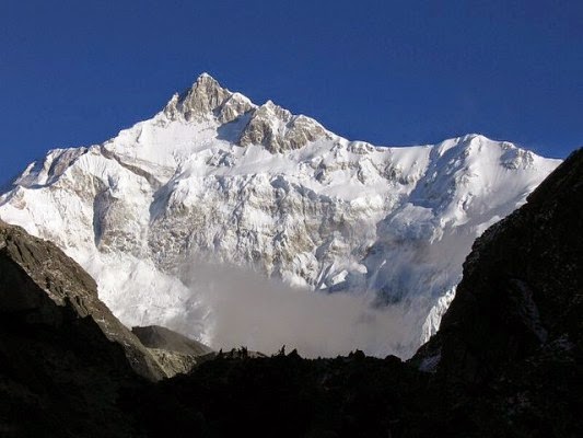
is the highest mountain peak in India,located at the border of Nepal and the India in Sikkim. Though its not a strange place to visit but indeed one of the must see place in India along with other four peaks of Great Himalayas, Mysterious Himalayan Yeti can be spotted here.

is the largest mangrove forest in the world and one of the most famous Ramsar sites in India. Sundarbans is a National Park, Tiger Reserve, and a Biosphere Reserve, famous for its man eater tigers.

in India is a region which has Naxalite–Maoist insurgency and suffer from the greatest illiteracy, poverty and overpopulation. Andhra Pradesh and Jharkhand are two most affected states of Red corridor.
SOURCE : INTERNET

These spooky apocalyptic images are not a
scene from “Walking Dead”, they were actually taken at one of the
biggest car cemeteries in the world – the Chatillion Car Graveyard,
Belgium.
According to an urban legend these cars
were left behind by US soldiers from World War II, who could not ship
them back to the US so they decided to hide them in a forest until they
could come back and retrieve them. The locals disagree and say that it’s
simply an old car dump of vehicles made after the WWII(World War-2)


Middle School Number 3 :
Following the meltdown of the Chernobyl Power Plant in 1986, the Ukraine government set up the Exclusion Zone, a quarantined area that extends 30 kilometers (19 mi) in every direction from the site of the reactor. Nearly 100,000 residents were evacuated from the Exclusion Zone, leaving behind their possessions, their homes, and, in many cases, their loved ones.Now, most of the Exclusion Zone is still uninhabited, although all of the buildings are still standing. One of those buildings, known simply as Middle School Number Three, is almost frozen in time at the moment of the disaster: Gas masks cover the floors, and chairs and desks still stand exactly as they would have on a school day 27 years ago, except for a few that were knocked out of the way as the students fled. If you want, you can actually visit the area right now with a guided tour, although this tour has certain rules you don’t normally hear on vacation—like stay on the concrete walkways, because the radiation is lower there, and don’t touch literally anything.


Welcome to the town of Setenil de las Bodegas in Spain, where around 3,000 inhabitants are living quite literally, under a rock.

The Fly Geyser, near Gerlach, Nevada, is strange because it somehow grows up. It is three meters high at the moment. It is interesting that this geyser is located on private area, so nobody can enjoy it from close. The owner is Bill Spoo, a man who rejects the opportunity to make a fortune from the tourists, and keeps the beautiful view just for himself and the few researchers and photographers who have to schedule a visit weeks before arriving.

Mount Roraima is located on the triple border point between Brazil, Guyana and Venezuela. It is weird because of its shape, but is also mysterious because of the clouds that are always near the peak and the endemic fauna. The tabletop of the mountain, which is the peak actually, is considered as one of the world’s oldest geological formations. It is believed that the plateau was formed by water and winds, but the reason why some species can’t be found anywhere else remain mystery.

Located in the Kara-Kum desert of Turkmenistan is the village of Darvaza (Derweze) near to where, in 1971, a team of Soviet prospectors allegedly drilled into a large chamber filled with natural gas. The roof of the cavern collapsed leaving a crater-like sinkhole some 25 metres deep with a diameter of approximately 60 - 70 metres. It soon became evident that natural gas was still rising into the crater from even deeper sources and the story goes that the decision was made to ignite the emissions rather than risk either a concentrated build-up of gas or local poisoning. According to various sources it has burned continuously since then and has apparently been named “The Gate to Hell” by the local people. However, another source that spoke with the guides from the region claims that it is a wholly natural phenomenon.

Found on both land and in the ocean throughout the Bahamas and the national waters of Belize are deep circular cavities known as Blue Holes which are often the entrances to cave networks, some of them up to 14 kilometres in length. Divers have reported a vast number of aquatic creatures some of which are still new to science. In addition, they’ve recorded chambers filled with stalactites and stalagmites which only form in dry caves. For the explorers this was proof that at one time, nearly 65,000 years ago, when the world was in the grip of the last major ice age, the sea level of the Bahamas was up to 150 metres lower than it is today. Over time the limestone of the islands was eroded by water and vast cave networks created. When sea levels rose again about 10,000 years ago some of these collapsed inwards and the Blue Holes were formed.

Enclosed by 752square kms of incredibly scenery, the Bemaraha National Park, situated in the west of Madagascar, was classified as a UNESCO World Heritage Site in 1990, and is home to the truly amazing stone forest known as the Tsingy.
From the Malagasy word “mitsingitsignia”, which means ‘to walk on tiptoe’, the term has been accepted in common language to denote the exceptional topography of eroded limestone, which may exist in other parts of the world, but nowhere as tall, slender and extensive as the spires here. An extraordinary world of forest canyons, humid caves and unique fauna and flora thriving in close proximity to one another.

The national park centers on two geological formations: the Great Tsingy and the Little Tsingy. Together with the adjacent Tsingy de Bemaraha Strict Nature Reserve, the National Park is a UNESCO World Heritage Site. The Tsingys are karstic plateaus in which groundwater has undercut the elevated uplands, and has gouged caverns and fissures into the limestone.
Because of local conditions, the erosion is patterned vertically as well as horizontally. In several regions on western Madagascar, centering on this National Park and adjacent Nature Reserve, the superposition of vertical and horizontal erosion patterns has created dramatic “forests” of limestone needles.
Tsingy can be translated into English as where one cannot walk barefoot. The unusual geomorphology of the National Park and Nature Reserve, means that the Site is home to an exceptionally large number of endemic species of plants and animals that are found only within extremely small niches in this place. For example, the summits, slopes, and bases of limestone needle form different ecosystems with different species clinging to their exceptionally steep slopes.

The formation of these unusual rocks actually began some 200 million years ago when layers of calcite accumulated at the bottom of a Jurassic lagoon, forming a thick limestone bed. Later tectonic activity elevated the limestone, and as sea level fell during the Pleistocene ice ages, even more of the limestone was exposed. Eventually, the ancient sediments were carved by monsoon rains, finally creating what we see today.
These are the most unusual and beautiful geological sites that you might ever come across. Not easy to get around, but stunning both in terms of their inherent natural attraction and the fabulous wildlife that exists here. It may not seem a perfect tourist destination, but you can be sure that if you ever do chance to actually see it in the flesh, as it were, you will want to go there again.

Roopkund
is a beautiful clear water Himalayan lake, located in the lap of
Chamoli district of Uttarakhand state India. The starting point of the
Roop kund is Debal. A picturesque lake is surrounded by snow covered
majestic Himalayan peaks and glaciers
This high altitude lake (4600m) lies in the lap of Trishul massif. A shallow lake, Roopkund has attracted attention by having human skeletal remains easily visible at its bottom. It is the highest peak, situated in Chamoli district of Garhwal. It is standing at 7802 meters; the peak finds its home in the state. The scene of countless pilgrimages, this brand new state has its roots steeped in the spiritual heritage of this great land.
The various sources of the Ganges Yamunoti, Gangotri, Kedarnath and Badrinath is the bernoth that draws devotees by the hordes. Here the tourist is replaced by the devout the young, the old, the fit and the infirm, all find their way here battling biting cold, high altitude sickness. Finding penance perchance in this hardship as the Gods almost seem to be close enough to touch. The mountains have many escapades to offer Valley of Flowers, the sacred Roop Kund and Dodital lakes, Milam glacier and Kuari Pass each of these have a distinct flavor – Rolling Meadows to killer ascents.
When ice melts in the glacial tarn of Roopkund, located 5,000 metres above sea level in Chamoli district, Uttaranchal, hundreds of corpses can be seen floating. Thus gets exposed a mystery that dates back to more than 60 years and has begun to be understood only recently.
In 1942, a forest guard chanced upon hundreds of skeletons at this tarn.
The remains have intrigued anthropologists, scientists, historians and the local people ever since. Who were these people? What were they doing in the inhospitable regions of the Garhwal Himalaya?
Many speculated, initially, that the remains were those of Japanese soldiers who had sneaked into the area, and had then perished to the ravages of the inhospitable terrain.
Those were World War II times and even the slightest mention of a Japanese invasion was bound to throw the area’s British administrators into the tizzy.
The matter was investigated and the speculation was put to rest: the corpses were said to date back to at least a century. But nobody knew when exactly. Some British explorers to Roopkund, and many scholars attribute the bones to General Zorawar Singh of Kashmir, and his men, who are said to have lost their way and perished in the high Himalayas, on their return journey after the Battle of Tibet in 1841.
But radio-carbon tests on the corpses in the 1960s belied this theory. The tests vaguely indicated that the skeletons could date back to anytime between the 12th and 15th centuries ad. This led many historians to link the corpses to an unsuccessful attack by Mohammad Tughlak on the Garhwal Himalaya. Still others believed that the remains were of those of victims of an unknown epidemic. Some anthropologists also put forward a theory of ritual suicide.
Local folklore has it that in medieval times, king Jasdhawal of Kanauj wanted to celebrate the birth of an heir by undertaking a pilgrimage to the Nanda-Devi mountains in the Garhwal Himalaya. However, he disregarded the rules of pilgrimage by boisterous singing and dancing. The entourage earned the wrath of the local deity, Latu. They were caught in a terrible hailstorm and were thrown into the Roopkund lake.

Folklore is not all myth
Now the first forensic investigation of the frozen corpses has concurred with the hailstorm theory. Scientists commissioned by the National Geographic television channel to examine the corpses believe that they died from sharp blows to their skulls. “We retrieved a number of skulls which showed short, deep cracks,” said Subhash Walimbe, a physical anthropologist at the Deccan college, Pune. Walimbe was a member of the team that visited the site.
“The cracks were caused not by a landslide or an avalanche but by blunt, round objects about the size of cricket balls,” he surmised. According to Walimbe, “The only plausible explanation for so many people sustaining such similar injuries at the same time is something that fell from the sky. The injuries were all to the top of the skull and not to other bones in the body, so they must have come from above. Our view is that death was caused by extremely large hailstones”. Another member of the team, Wolfgang Sax, an anthropologist at Heidelberg University in Germany, cited a traditional song among Himalayan women that describes a goddess so enraged at outsiders who defiled her mountain sanctuary that she rained death upon them by flinging hailstones “hard as iron”.
“We were amazed by what we found,” said Pramod Joglekar, a bio-archaeologist at Deccan College, Pune. “In addition to skeletons, we discovered bodies with the flesh intact, perfectly preserved in the icy ground. We could see their hair and nails as well as pieces of clothing,” he said. The scientists found glass bangles, indicating the presence of women.
The team also found a ring, spear, leather shoes and bamboo staves. This has led them to hypothesize that the corpses were those of pilgrims. The scientists estimate that as many as 600 bodies may still be buried in snow and ice by the lake.

Pilgrims perish
The samples were sent to the Radiocarbon Accelerator Unit of Oxford University, uk where the date of death was established at about 850 ad. The team has yet to resolve the identity of the victims, though.
Meanwhile, scientists at the Centre for Cellular and Molecular Biology, Hyderabad have also undertaken tests on skeletal remains. Lalji Singh, the director of the centre, said that his institute had conducted studies on the dna of 31 samples of bone and muscle taken out from the remains. “Three samples have unique mutations in the mitochondrial DNA which are not found anywhere in the world but only in a particular group of people from Maharashtra,” he said. Singh, however, refused to mention the ethnic group. He said analysis of two other samples matched with some people living in Garhwal even as further studies on all the 31 samples were still on to find out more accurate facts. D K Bhattacharya of the National Geographic team agrees: “Only a few have the characteristics of the Mongoloid hill people of the Himalaya,” noted this scholar from the University of Delhi. It’s quite possible that the pilgrims employed these local people as porters. After all, Roopkund is almost 35 km away from the nearest human settlement and it’s virtually impossible for outsiders to venture into the area without taking the help of local people.
Need protection
It is quite unfortunate that the local administration has made no organised attempt to protect this site. Skeletal remains and other articles of those who perished ages back are reported to have been diminishing fast from here. Lack of administrative will and a general indifference has denied this destination its due place on the international tourist map. In the ceaseless efforts to win over nature sometime we emerge as victorious though losing the battle is also an integral part of the game. The Roopkund remains an indicator of the latter.


Known as a 'super-Earth', the planet Gliese 163c is about 50 light years away and lies just on the edge of its star's habitable zone. It isn't clear if the planet is a rocky world or a small gas giant but at seven times the mass of Earth it is considerably larger than our own terrestrial sphere. There is a small chance that the planet will pass in front of its star from our perspective which would offer scientists the chance to learn more about it.
"There are a wide range of structures and compositions that allow Gliese 163c to be a habitable planet," said astronomer Xavier Bonfils whose team made the discovery.
The
Planetary Habitability Laboratory (PHL) at the University of Puerto
Rico at Arecibo keeps a catalog of the alien worlds it considers good
candidates to host life. The newly discovered Gliese 163c ranks fifth on
the list.

Magnetic Hill in Ladakh - There is a hill in Ladakh region of Kashmir which can pull a car parked in neutral with the speed of 20km per hour. Apparently this happens because the hill possesses magnetic power. Its not just cars but planes that too are attracted by the Magnetic Hills. This is the reason why Indian Air Force has asked pilots to avoid flying over the Magnetic hills. To visit the Magnetic hill, you will have to travel Leh. From Leh you can hire a local guide who would take you to Magnetic hill. There isn't much to see there. Only a sign board has been placed by officials to indicate Magnetic Hill.
 The well known statues on the Easter Island, the rapa nui, still remain mystery for the researchers. The statues are over 50 feet tall, but no one has a clue who built them, why they built them, how they were brought there, and so on. One of the theories is that a civilization has lived here long time ago, but the people ate everything on the island and either moved somewhere else or were exterminated.
 The question about the triangle that swallows ships, planes and all the people with them still waits for its answer. So many ships and planes have disappeared and so many disasters have happened in the area between Bermuda, Puerto Rico and Miami, and many theories have appeared as well. From compass variations, gulf streams, rogue waves to human errors and conspiracy theories – anything is possible, but none of them is proved yet. However, it’s still one of the most traveled routes in the world.
Atlantis, the Lost City everyone is talking about. Where is it, is it real? Why are there rumors if it's not true? Here we will explore the myths and realities of the Lost Continent of Atlantis. Sit back, relax and take a wonderful ride!The city of Atlantis, if you hear about it, one would think that it would be located in the Atlantic Ocean, hence the name. But researchers have been looking for this continent for years. The continent was mentioned in many religions and folklores, that it became a possibility that it truly does exist. But if it does, where is it and has it been found by scientists yet, or have they think they have found the Lost City or Continent of Atlantis?

The great philosopher, Plato, wrote in his Critias, that he believed that a great continent was extremely technologically advanced, and that this continent had been destroyed and lost by a rush of ocean covering the evidence to us to this day. Plato had believed that Atlantis was located in the Atlantic Ocean somewhere. In fact, the reason why the Atlantic Ocean is called such today, is because of the Atlantean theory. Plato believed that Atlantis was a sunken continent approximately the size of Libya and Asia puttogether. That would be about 5 to 10 million square kilometers hidden below a large oceanic surface!
Monoliths, similar to the monoliths in Easter Island, supposedly are a "signature" of the Atlantean culture. Some believe this culture survived on to Islands and lands such as Easter Island and other various areas still leaving scientists and archeologists befuddled. Pyramids, such like those found in Egypt and other ancient sites, are also a supposed "signature" of the Atlanteans.
Plato believed that Atlantis had a great army, probably of around 1.2 million armed men. He also believed that the army had a vast number of chariots. Horses were definitely used. This was the theory that had caused many to believe that the horse that evolved from Asia became domesticated in Atlantis. This remains a striking detail, because scientists and archeologists cannot determine precisely when the domestication of the horse occurred.
 Some scientists believe that the sinking of Atlantis was caused by a great "Ice Age." Pillars are abundant on the oceanic floors, but are these pillars naturally made or manmade?
The "Sleeping Prophet", also known as Edgar Cayce, had believed he was an Atlantean himself. He was a prophet that believed that spirits spoke to him in his dreams. The dreams revealed revelations of great extent for his own life and many others. His prophetic visions attracted many people, which in turn made many seek out his help in life through his "seeing eye." Cayce believed that he was being told his clairvoyances from Atlantean gods and spirits.
One prophecy that Edgar Cayce had made, did not come to pass, this was regarding the lost continent of Atlantis. Cayce prophesized that the lost island of Atlantis would emerge from the ocean in 1968 or 1969. Cayce also suggested that the island was located near the Bermuda island of Bimini.
The lost continent to this day, has many possibilities of where it could "be," however, no scientific evidence that is strong enough to prove Atlantis had existed has been yet found. But that doesn't mean that it doesn't exist!

Please Do Watch This Video:
Imagine a beach where the sky is always blue, it’s never too hot or cold, the water isn’t filled with salt and pollution, and the surf is always perfect – welcome to Ocean Dome, the world’s only indoor beach. Amazing photos.
Ocean Dome has its own flame-spitting volcano, crushed white marble "sand", and it also boasts the world’s largest retractable roof, providing a permanently blue sky. Temperature, wind and humidity are closely controlled to provide an ultra-safe "sea-side" experience.
Every hour, the volcano erupts and the hi-tech wave machines start up, starting a few minutes of sanitised surfing.

Ocean Dome is known as the world’s largest indoor water park (300m-100m-38m),
with a retractable roof. The air temperature is always kept around 30°C
and the water temperature is kept at around 28°C.
The name Seagaia is a combination of the words “sea” and “gaia”,
which is Greek for “earth”. It’s located near the Pacific Ocean on Kyushu Island.


Entrance costs US$50, which seems especially expensive given that there is a free, natural beach only 300 metres away.
Ocean Dome has its own flame-spitting volcano, crushed white marble "sand", and it also boasts the world’s largest retractable roof, providing a permanently blue sky. Temperature, wind and humidity are closely controlled to provide an ultra-safe "sea-side" experience.
Every hour, the volcano erupts and the hi-tech wave machines start up, starting a few minutes of sanitised surfing.
Ocean Dome is known as the world’s largest indoor water park (300m-100m-38m),
with a retractable roof. The air temperature is always kept around 30°C
and the water temperature is kept at around 28°C.
The name Seagaia is a combination of the words “sea” and “gaia”,
which is Greek for “earth”. It’s located near the Pacific Ocean on Kyushu Island.
Entrance costs US$50, which seems especially expensive given that there is a free, natural beach only 300 metres away.
Introduction:Nazca Lines are the most outstanding group of geoglyphs in the world. Etched in the surface of the desert pampa sand about 300 hundred figures made of straight lines, geometric shapes and pictures of animals and birds - and their patterns are only clearly visible from the air.

The high desert of Peru holds one of the most mystifying monuments of the known world—the massive-scale geoglyphs known as the Nasca Lines. Ranging from geometric patterns to “drawings” of different animals and stylized human-like forms. The ancient lines can only be truly taken in, their forms discerned, from high in the air, leaving generations mystified as to how these precise works could’ve been completed long before the documented invention of human flight. Are the lines signs left by an alien race? Landing strips for UFOs? Relics of a ancient people far more advanced—capable of human flight—then previously imagined?
These Are Some Of The Lines :
The Condor

The "Giant"

The Heron

The Pelican

The Hummingbird

The Hands

The Dog

The Spider

The Monkey

The high desert of Peru holds one of the most mystifying monuments of the known world—the massive-scale geoglyphs known as the Nasca Lines. Ranging from geometric patterns to “drawings” of different animals and stylized human-like forms. The ancient lines can only be truly taken in, their forms discerned, from high in the air, leaving generations mystified as to how these precise works could’ve been completed long before the documented invention of human flight. Are the lines signs left by an alien race? Landing strips for UFOs? Relics of a ancient people far more advanced—capable of human flight—then previously imagined?
Etched, as if by giants, onto the arid moonscape of Peru’s southern desert lies one of man’s greatest mysteries; the Nasca Lines. More than 15,000 geometric and animal-like patterns have been discovered criss-crossing the pampas like a vast puzzle. Who built them and what was their purpose? Ancient racetracks, landing strips for aliens, or perhaps a giant astronomical calendar? And are the Lines connected to the gruesome discovery of large cache’s of severed human heads. Now, after decades of misunderstanding, modern archaeology may finally have the answer.
Excavations in the surrounding mountains are uncovering extraordinary clues about the people who made them and why. A long since vanished people, called the Nasca, flourished here between 200BC and 700AD. But the harsh environment led them to extreme measures in order to survive.
Archaeologist Christina Conlee recently made an extraordinary find: the skeleton of a young male, ceremonially buried but showing gruesome evidence of decapitation. In place of the missing human head, a ceramic “head jar” decorated with a striking image of a decapitated head with a tree sprouting from its skull.
Conlee wonders who this person was? Why was he beheaded and yet buried with honor. Was he a captive taken in battle, or could he have been a willing sacrifice? And did his decapitation have anything to do with the lines? The discovery of large caches of human heads adds grisly weight to Conlee’s theories and helps unravel on of man’s great mysteries.
The Condor
The "Giant"
The Heron
The Pelican
The Hummingbird
The Hands
The Dog
The Spider
The Monkey


